It was the Beach Boys that started
me thinking about Post-It Notes. Now there’s a statement that requires an
explanation! For me, the sign of an especially good non-fiction read is the
total count of Post-It pieces protruding from its pages as I make my way
through. Case in point at present happens to be a library copy of Beach Boy
Brian Wilson’s 1991 autobiography Wouldn’t
It Be Nice. Now believed to have more likely been the work of his late
Svengali shrink Dr. Eugene Landy, the tome has been pointing me to a number of
the group’s more obscure tracks on YouTube and in the iTunes store, hence the
resulting mass of Post-It fragments.
My six-shelf World War II bookcase, long ago filled to
overflowing, is an ode to the Post-It Note. From Ambrose to Wurst, from
Michelin Green Guides to the folded surfaces of European road maps, a plethora
of affixed strips have found permanent homes. The smallest-sized, plain yellow
pads are my workhorse since a single note can be neatly torn to mark four
pages. And I’ve learned to accept no imitations, as lesser brands have failed to
stay in place on my maps and guide book pages when in use in the field.

In a general sense, marked pages helped me to write my Elwood
and Elden books, and to plan a decade of trip itineraries ranging from
Normandy, France, to beyond the German/Polish border. A “sticky note” marks the
spot in Brave Men (1944) where war
correspondent Ernie Pyle name-checks General Omar Bradley’s orderly, Corporal
Frank Cekada of Calumet, a Copper Country city right here in the Upper
Peninsula. (“Frank was 24, and before the war was, of all things, a
bartender.”)
A series of yellow strips still mark my surprise discovery of
a local World War II Gold Star research subject, a U.S. Coast Guardsman from
Munising with marital ties to Newberry, in the pages of Richard Tregaskis’ Guadalcanal Diary. While my previous
finds on this Yooper serviceman were in the deceased sense, in this book he
came to life. (“Coxswain Charles N. Stickney [of Newberry, Mich.] swung our
helm sharply to the right and opened the throttle.”)
One of the greatest and most welcome drains on my Post-It
Note supply came courtesy of a new friend Jim and I made in 2009 during our
first solo travels around Normandy, Alan Amelinckx, then-assistant
superintendent of the Brittany American World War II Cemetery near St. James. Through
his recommendation, I greatly expanded my knowledge of what went on beyond Utah
and Omaha by reading John C. McManus’ The
Americans at Normandy: The Summer of 1944 – The American War from the Normandy
Beaches to Falaise.
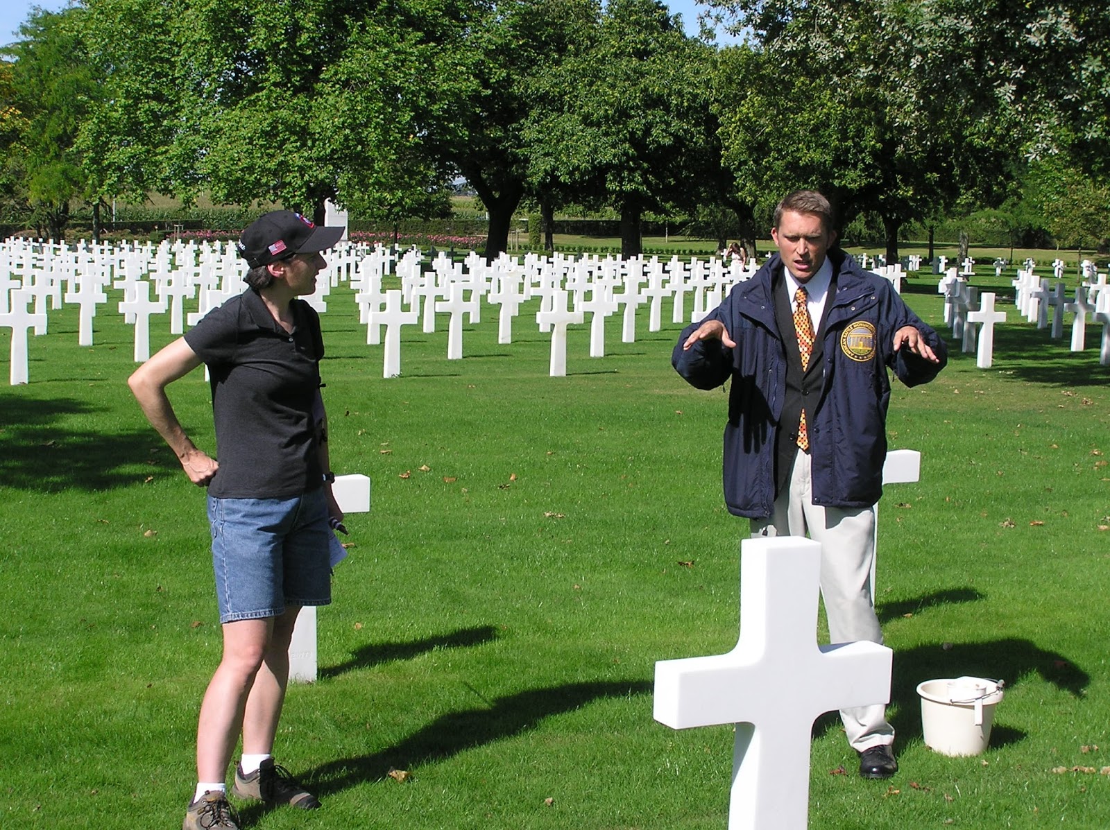 |
| With Alan Amelinckx, Brittany American World War II Cemetery, September 2009. (Jim Koski photo) |
The
following year, Jim and I devoted parts of several days to focusing on McManus’
writings, finding ourselves often on the proverbial road less traveled and
continuously wide-eyed, as we matched our visual “nows” with The Americans at Normandy’s vivid
descriptions of 1944.
Tuesday,
October 12th’s to-do list was particularly intensive: St.-Lô to St. Gilles,
Canisy, Le Mesnil-Herman/Hill 183, Coutances, Roncey, Guéhébert to Grimesnil
(La Lande des Morts), Villebaudon to Tessy-sur-Vire and Pont-Farcy, St.
Sever-Calvados, Villedieu-les-Poêles to Brécey, and St. Pois. Excerpts from my
trip after-action report tell the tale of that day…
“Today’s
itinerary was designed to make maximum use of John C. McManus’ The Americans at Normandy: The Summer of
1944—The American War from the Normandy Beaches to Falaise, so much so that
I had resorted to photocopying a portion of the Michelin Normandy map
encompassing the area from St.-Lô in the north to Avranches in the south, Vire
to the east and the Normandy coast to the west, and highlighting specific
stretches of road between several sets of municipalities.” Since the
alternative would have been peering for place names in the fine print of a
folding map while repeatedly referring to the McManus book, we had no desire to
do those things, and do them repeatedly, on the fly.
“Despite
a definite chill in the morning air, we felt very much on our game, the sun was
already at work for us overhead and we had the early makings of Ducey’s market
day to explore before covering those 80 kilometers to St.-Lô in the
Citroën…Vendor offerings included a boulangerie wagon well-stocked with
honest-to-goodness, made-with-love, full-sized pain au chocolat.”
 |
| Market Day in Ducey. (Jim Koski photo, October 2010) |
To
our relief we managed to reach the western edge of St.-Lô without wandering
into its interior maze (bad memories from 2009) and went for objective #1,
following westbound D972 to St. Gilles, where armor and infantry had met armor
and infantry in late July of 1944. One of the most vivid World War II
memoirists I’ve read, Lt. George Wilson, documented his first day in combat in
this area—July 26th, 1944—and his words figured often into the section of the
McManus book we were revisiting. My crib notes describe Wilson following this
violent route, which included the carnage left by the previous two days’ Allied
carpet bombings intended to finally drive German forces south.
Bodyguard of American planes flying
overhead. Craters in the road were a great obstacle. German road block several
hundred yards north of St. Gilles.
We each
felt a chill go down our spine, pulled to the roadside looking north from the
fringes of the town of St. Gilles. A harmless scene now but…
St. Gilles at 1530 but continued moving
toward Canisy.
The
D77 runs south out of St. Gilles toward Canisy, an Allied air target in those
last days of July ’44. Lt. George Wilson had traveled this route on foot with
the 4th Infantry Division men he commanded.
Bombed out overpass on edge of town used by
Germans as fortified position. American fighter-bombers devastated the town.
 |
| Canisy overpass. (Jim Koski photo, October 2010) |
While
long since rebuilt, that overpass leading into St. Gilles gave us a bigger
chill yet. Even in a photograph Jim
snapped, it has the power to creep one out when placed in that World War II
context…Lt. Wilson’s men had proceeded among columns of American G.I.s toward
Le Mesnil-Herman in darkness, encountering enemy armor in the process. Le
Mesnil-Herman/Hill 183 would not be taken until 1500 of the following day, July
27th.
Contact with the enemy (including armor
against armor) at a road intersection 300 yards north of the town.
We
contemplated the countless cars that pass through that intersection just
preceding Le Mesnil-Herman every day, every week, each year, their occupants’
minds free to think of anything but the violence of 1944.
Just
south of Coutances, we took the D27/D58 southeast toward Roncey.
American fighter-bombers massacred a German
convoy in this vicinity on the afternoon of 7/29/44. The McManus book says the
slaughter went on for six hours.
Next
up, a few kilometers to the southwest, we jumped onto the D302 to travel a
stretch of road between Guéhébert to Grimesnil, an area known locally as La
Lande des Morts (roughly translated, “the Land of the Dead”), dating back to
15th Century battles between the English and the French, but living (?) up to
its name again in World War II.
According
to the McManus book, at 0100 on July 29th into July 30th, 1944 “a wandering
column of Germans, estimated to number 2500 soldiers and at least 90 vehicles,
ran right into the Americans at Grimesnil…Tank fire, mortar fire, and
especially artillery fire scythed through the enemy vehicles.” With the arrival
of dawn, “the Americans at the Land of the Dead beheld a scene out of hell itself…the
land was littered with the bodies of dead soldiers.”
 |
| The D302, Guéhébert to Grimesnil. (Jim Koski photo, October 2010) |
Even
today the road between Guéhébert to Grimesnil remains narrow and extremely
high-hedgerowed—like walls on both sides of the road, and it does not require a
lot of effort to conjure images of the above scenario when you are there. You
also realize though how far those images are from the actual brutal sights,
sounds and earth-shaking blasts of that violent time.
With
Virgin Radio-France as our ongoing soundtrack, we D7’d south to the eastbound
and elevated D13 with panoramic views to the north and straight ahead, through
Villebaudon and descending slightly into unexpectedly charming Tessy-sur-Vire.
We had planned to continue on through but were drawn to take a closer look at
the very much rebuilt church on its dominant perch over most of the town. Upon exiting
the car, we heard the joyful shrieks and voices of small children at play in a
walled and gated schoolyard, sounds that followed us down the street, around
the church and into the churchyard, the sound of freedom. I hoped that
somewhere all the Allied soldiers lost in battle in this vicinity were witness
to the same.
 |
| From the Tessy-sur-Vire churchyard. (Jim Koski photo, October 2010) |
The
sprawling churchyard included Tessy-sur-Vire’s World War I monument as well as
a memorial to the town’s liberators of August 2nd, 1944, the U.S. 30th and 29th
Infantry Divisions. Over a low wall
lined with flowering plants lay several intersecting streets, including the
road out of town. Switching the Citroën over to the D21 south, we continued our
descent a few more kilometers into the “Valley of the Vire” to Pont-Farcy to
check out a monument honoring the 35th Infantry Division, particularly those
whose lives were given in the name of freedom. Big Bay, Michigan’s PFC Everett
Beerman would have been among Pont-Farcy’s August 2nd, 1944, liberators,
putting him 51 kilometers (just under 32 miles) north of and nine days away
from becoming a war fatality at Mortain.
We
had just one more stretch of road to survey—the D999 south into Brécy, which we
could have accomplished by taking a main highway over to Villedieu-les-Poêles
but we felt like meandering and had the time so we chose the D52/D374 southeast
to the D81 through St.-Sever-Calvados and the Bois de St.-Sever. Winding uphill
out of St.-Sever-Calvados we soon pulled over, awestruck by the town, which was
now below us, and the rest of our surroundings—up high and very
photogenic.
We
left the car behind for a few and ventured down a steep, inviting alley back
into the heart of the village. We tiptoed inside the huge church (the kind
where you’re sorry if your foot accidentally bumps a chair leg because you know
it’s going to echo like a thunderclap!), which Jim’s camera liked, and
inspected the traditional peaceful spot outside devoted to a World War I
memorial, a memorial to local World War II resistance casualties, and a third
monument emblazoned with a full-color U.S. armored forces insignia and the
outline of an army tank recognizing our 2nd Armored Division (“Hell on
Wheels”): They gave their lives so we
could be free.
 |
| War memorials, St.-Sever-Calvados. (Jim Koski photo, October 2010) |
The
D81 met the D999 a fair enough distance north of Brécy that we felt we would be
able to appreciate the historical aspect of the roadway and the town. In
hindsight though, with the town as bustling and rebuilt as it was when we
passed through, I had a difficult time envisioning. “Buildings sit pretty tight
to the not very wide streets,” I jotted in my trip journal.
Bombed from the air by the Americans on the
evening of 7/31/44. Ground forces arrived to see German soldiers lounging on
the town curbs as if nothing had happened. The subsequent fighting there
continued through the night.
Itinerary
home stretch. Still preferring zigzagging to traveling in a straight line, we
sped northeast up the D39 to St.-Pois and then northwest up the D33 to
Villedieu-les-Poêles…
Perhaps
the highlight of our McManus-inspired explorations, however initially
ill-fated, was our beyond-off-the-beaten-path quest to find Le Carrefour a
couple of trip days later.
 |
| Leaving Caumont l’Eventé via the road less traveled. (Jim Koski photo, October 2010) |
Traveling
D roads north from Caumont l’Eventé, where we had made a 5th Infantry
Division-related stop, we backtracked west on the D15, looking for an exit on
our right toward Cartigny. Check. The next road left should have taken us
directly to Le Carrefour. Left taken, no Le Carrefour, clock ticking. As we
tried a different northbound road off the D11, we were ecstatic when we spied a
monument of some kind adorned with U.S. and French flags amidst the soggy
farmland—only to discover it marked the site of air field A5, World War II home
to the U.S. 404th Fighter Group. Too defeated and behind schedule to search any
further, we followed the next available road west, intending to catch a main
road north toward Omaha Beach.
 |
Merci to the citizens of Normandy! It's just not the memorial we were looking for... (Jim Koski photo, October 2010)
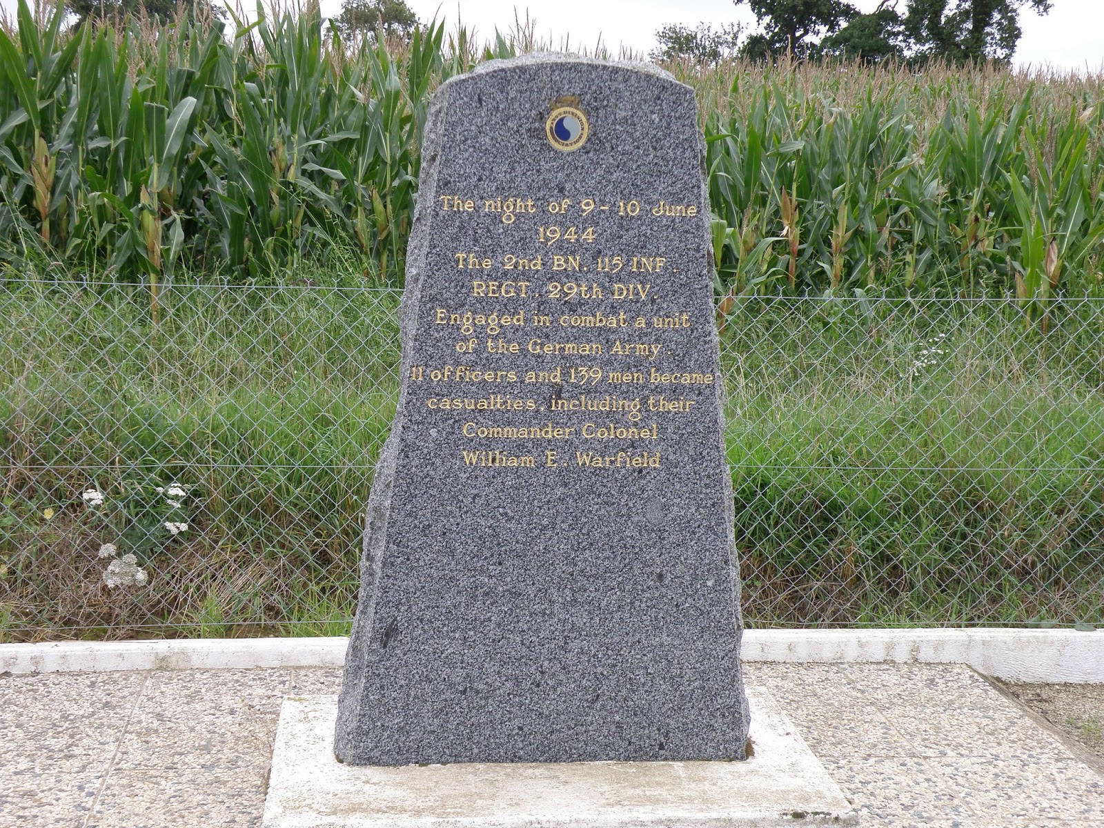
Suddenly we saw a sign for the D202 veering left, its destinations including LE CARREFOUR. And so we would ultimately stand before the Colonel William E. Warfield monument, gazing beyond it at cornfields that once held an apple orchard, where, on the night of June 9th into June 10th, 1944, 150 men from Warfield’s 2nd Battalion of the 115th Infantry Regiment, U.S. 29th Infantry Division, were slaughtered with cold calculation in then-hedgerowed fields by German forces. |
 |
Voilà!
(Jim Koski photo, October 2010)
|
From
my McManus book crib notes: The weary infantrymen made it to Le Carrefour at
0200 and were directed to their positions—the two orchards being about an acre
apiece and surrounded by a hedgerow on every side. They had marched 15 miles in
20 hours (including arduously crossing a slimy, stinking swamp) and spent much
of the day fighting stubborn German strong points. Few of them had eaten and,
officers included, they had little strength left. “Thus most of the troops
simply flung themselves to the ground and went to sleep.”
A
half hour later many of them died. “An entire German artillery battalion,
reinforced with tanks and infantry from the 352nd Division, caught 2nd
Battalion by complete surprise.” Just after 0230, “the enemy pointed their
weapons—everything from self-propelled artillery pieces to rifles—over a line
of hedgerows and opened fire at nearly point-blank range into the orchards
where the Americans were sleeping.” Lt. Col. Warfield, who was machine-gunned
in the road, died with his pistol in his hand.
In a
matter of seconds we were at a crossroads near the community we had been
seeking and there by the roadside was the gray marble marker remembering the
ambushed Americans who had fought their way inland from Omaha Beach.

As I near the 16-year mark
of my research mission, and the 18th year since Saving Private Ryan spurred me toward it, untold numbers of Post-It
Note pieces have become markers following me on an incredible journey. And
where John C. McManus’s Normandy book is concerned, I am grateful every day to
Alan Amelinckx for the heads-up on this essential read while heading through my
fifth year of wondering when some smart and up-to-the-task company or guide will
decide there’s a market for going beyond the beaches, and fill the historical gap
by offering a comprehensive tour of the Americans’ entire June through August Normandy experience.